Hydrographic Surveying Practice Exam
$69.00
- Buy to unlock unlimited access to all Quiz questions and Answers in this Quiz.
- After purchase you can print a PDF of the whole quiz at any point. The PDF will contain the questions and the correct answers.
About this Exam
Hydrographic surveying is a dynamic and essential field dedicated to mapping and measuring the underwater world. From ensuring safe navigation through intricate shipping lanes to guiding offshore energy projects and managing coastal environments, the work of a hydrographic surveyor is critical to the marine economy and safety.
This Hydrographic Surveying Practice Exam is specifically designed as a comprehensive preparation tool for professionals and students aspiring to achieve official certification in this specialized discipline. It is a simulated environment that allows individuals to test their knowledge and application skills against the high standards required by recognized international bodies, paving the way for further qualification and career advancement.
Ready to test your knowledge?
Buy Now to Access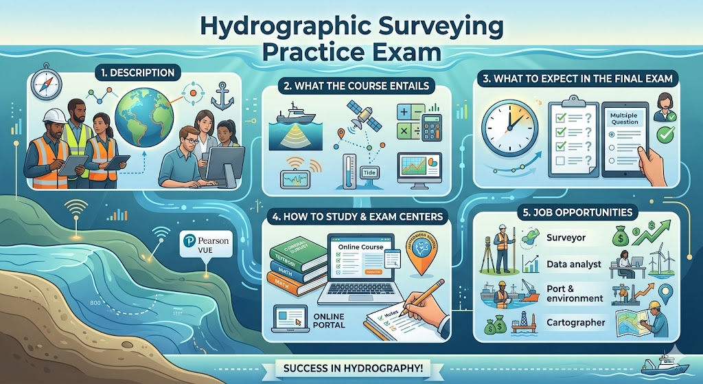
Additional Information
What the Course Entails and Exam Details
This practice exam covers the vast, multi-disciplinary knowledge base that defines the world of hydrographic surveying. While "the course" refers to the broad learning objectives and standards the exam is built upon, the practice exam itself simulates a comprehensive assessment of competence. Candidates using this resource will sharpen their expertise in several core domains, including:
Geodetic Positioning & Datums: Understanding the Earth’s shape, coordinate systems, global navigation satellite systems (GNSS) like GPS, and the vital importance of horizontal and vertical datums.
Acoustic Principles & Depth Measurement: Mastering the theory of sound propagation in water and the precise operation of single-beam and multi-beam echo sounders, side-scan sonar, and other bathymetric technologies.
Tides & Sea Level Variations: Comprehending tidal forces, measurement methods using tide gauges, and the application of essential vertical tidal corrections to sounding data.
Survey Data Acquisition & Processing: Learning to plan, execute, and troubleshoot survey operations, including data filtering, cleaning, error analysis, and the synthesis of raw data into accurate charts.
Marine Geophysics & Seabed Classification: Interpreting seabed characteristics and using geophysics to map the seafloor morphology and composition.
Project Management & Safety: Understanding standard hydrographic procedures, safety regulations at sea, and the elements of project planning, reporting, and quality control.
The practice exam consists of multiple-choice and complex conceptual questions that reflect the multi-faceted nature of the real-world surveyor’s role, testing both theoretical understanding and practical decision-making.
What to Expect in the Final Exam
While this tool is for practice, understanding the typical structure of the official, final comprehensive certification exam that this practice exam simulates is crucial. High-stakes hydrographic surveying exams, often administered by professional bodies or accredited institutions (some aligning with IHO Cat A/B standards), are notoriously rigorous.
The final official exam commonly features:
Comprehensive Coverage: A multiple-hour, closed-book assessment testing all elements within the syllabus described above.
Multiple-Choice and Short Answer Questions: A significant portion is often dedicated to multiple-choice questions to cover extensive theoretical ground. This can be combined with structured short-answer and problem-solving questions.
Practical & Technical Scenarios: Questions often present real-world survey scenarios, calculation problems, chart interpretation tasks, and data processing conundrums, requiring candidates to apply their knowledge in a critical manner.
Rigorous Timing: Expect a significant time constraint (often 3 to 4 hours or split into multiple sessions), demanding efficiency in recall and analytical thought.
Strict Proctoring & Identification: Formal exams are held in controlled environments with strict proctoring and require proper identification.
Minimum Passing Score: Candidates typically must achieve a substantial score (e.g., 70% or higher) to pass.
Preparation using a quality practice exam is the most effective way to become familiar with the style, structure, and depth required for this significant final challenge.
How to Study and Exam Centers
Preparation for both the practice exam and, ultimately, the official certification requires dedicated study and a strategic approach.
Study Strategies:
Utilize Recognized Resources: Base your studies on key textbooks in the field, IHO (International Hydrographic Organization) publications, and official course materials. Pay special attention to IHO S-44 standards for hydrographic surveys and relevant IBSC (International Board on Standards of Competence for Hydrographic Surveyors) guidelines.
Focus on Theory First: Solidify your understanding of geodesy, acoustics, tidal theory, and the fundamental operation of survey instruments before diving into complex problems.
Practice Calculations: Master geodetic coordinate conversions, tidal height calculations, sonar range and error calculations, and the essential applications of trigonometry and physics.
Hands-On Experience Matters: Nothing replaces real-world experience. If possible, seek training or entry-level positions to apply your knowledge and understand the complexities and challenges of conducting surveys at sea.
Identify Weak Areas: Use the results of your practice exams to pinpoint subjects where your understanding is less robust and allocate additional study time to those topics.
Simulate Exam Conditions: When taking this practice exam, try to do so in a quiet environment, adhere strictly to a time limit, and avoid using any reference materials to truly test your readiness.
Join Professional Organizations: The Hydrographic Society or other marine technology-focused groups offer networking, webinars, and specialized knowledge resources that can be very beneficial.
Exam Centers & Registration:
Practice Exam: As a practice resource, this specific exam is likely accessed via an online learning portal or downloadable platform, allowing you to take it at your convenience.
Official Certification Exams: When you are ready for the final, official certification, testing procedures vary by the granting body.
Accredited Institutions: Certifications (like IHO Category A/B) are often awarded upon the completion of a full course at an accredited school or university, where the final exam is held. Check for globally recognized training programs.
Professional Bodies: In some regions, professional associations administer the Certified Hydrographer title or similar, and may use specific, authorized testing centers, potentially including networks like Pearson VUE, or their own designated examination venues.
Check with Specific Bodies: Always check the current requirements and registration details directly with the official certification panel or the authorized academic institution you are aiming to qualify through. They will provide the latest information on accredited training paths and final assessment locations.
Job Opportunities from the Course
Achievement of a hydrographic surveying certification, validated by comprehensive study and practice, opens doors to a vast array of engaging and well-compensated career paths. Your skills will be in demand by government agencies, private companies, and research institutions globally. Possible career paths and job titles include:
Category B Hydrographic Surveyor
Category A Hydrographic Surveyor (Often with advanced management or research focus)
Marine Geophysicist / Hydrographer
Offshore Surveyor (Supporting oil, gas, and renewable energy sectors)
Hydrographic Data Processor / Analyst
Marine Cartographer / GIS Specialist
Coastal Zone Manager
Survey Project Manager / Party Chief
Marine Scientist / Oceanographer
Nautical Chart Producer
Dredging Surveyor
Pipeline and Cable Route Surveyor
Navigation & Safety Officer (Utilizing hydrographic knowledge)
Research & Development Specialist (Developing new survey technologies)
Your journey in hydrographic surveying is a critical contribution to marine safety, sustainable resource use, and oceanic understanding. This practice exam is your first step on that promising and impactful career path. Good luck with your studies and preparation!
Frequently Asked Questions
Reviews
5.0
Based on 0 reviews
Leave a Review
No reviews yet. Be the first to review!